
Newton Abbot had close links with the Newfoundland cod trade – and with a Devonian who ‘claimed’ Newfoundland for the British Empire in 1538.
From the 1840s to the 1890s the Ordnance Survey completed Town Plans of the larger towns in Britain – those with a population of over 4,000. Newton Abbot was surveyed in 1888 with maps published in 1889. Maps were produced at 1:500, so show a lot of detail with 15 maps covering the town. These are a valuable source of historic geographical information.
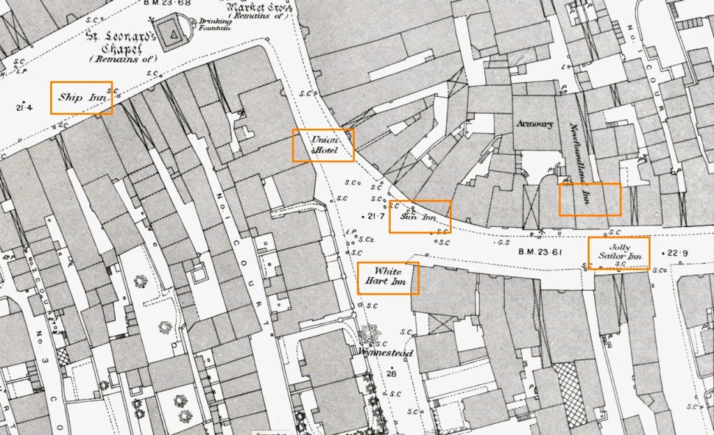
I have reproduced two maps at the bottom of this page, the first an extract from part of just one sheet showing the lower (western) end of East Street to its junction with Powderham Road. The ‘clock tower’ as most people know it is in the top left of the map and described as the “remains of St.Leonard’s Chapel”.
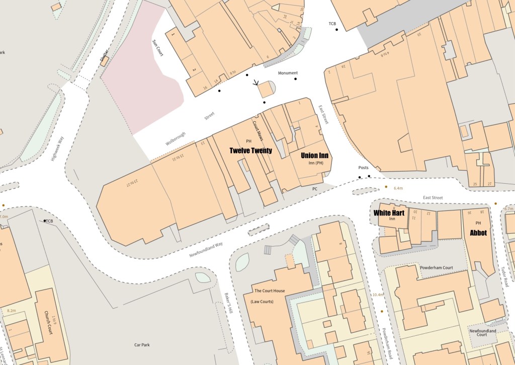
The second map shows roughly the same area as it is known to us today, with the main feature being the substantial demolition that took place to build Newfoundland Way.
Pubs
Newton Abbot has more pubs than most towns of its size, but there were more in the 19th century than there are now, and the character (and even name) of some of those that remain has changed beyond recognition.
In 1888 there were six pubs marked on this section of map. I have highlighted these with orange rectangles. These are (from east to west):
1. Jolly Sailor
2. Newfoundland Inn
3. Sun Inn
4. White Hart Inn
5. Union Hotel
6. Ship Inn
Of these four remain to this day. The Jolly Sailor became the Jolly Abbot and since 2023 simply ‘Abbot’. The White Hart and the Union remain unchanged and the Ship Inn was known as ‘Ships’ for a while and is now the ‘Twelve Twenty’.
The Newfoundland Hotel was associated with the cod trade in Newfoundland, which was important to the town from the mid-16th century. More on that later.
Ships, seafarers, fishing and Newfoundland
This area of Newton Abbot has been closely linked with the Newfoundland fishing industry since that part of the world became the first British colony in 1538. The colony was founded by Sir Humphrey Gilbert of Compton, just a few miles to the south of Newton Abbot. From this date ships frequently set off from Newton Quays (yes, the river Teign was navigable for small ships at that time) and men used to hang out in pubs hoping to be selected for seasonal work, usually the Dartmouth Inn (further up East Street) and the Newfoundland Hotel (shown on the map as an ‘Inn’).
When the Newfoundland Hotel was demolished (along with the Sun Inn) it was decided to name the new road to be built as Newfoundland Way, as it is still known today. The Newfoundland trade peaked in the 1770’s and declined slowly after that. It is, in my view, a great shame that pub names have changed as if to erase this history that was so important to the town for centuries. No more ‘Ship Inn’ or ‘Jolly Sailor’.
On their return to Newton Quays ships would offload their cargoes of dried cod, which was stored in special depots, notably in East Street and St.John’s Street. The latter was named after the capital of Newfoundland, St.John’s. Newton Abbot gained a great livelihood from this trade, including the manufacture of ships ironmongery and ropes, fish hooks, fishermans knives, fishermans boots and so forth. Ridgeways the bootmaker made fishermans boots and sadly closed in 2020.
Incidentally, the map you will see an armoury which is now part of (or very close to) the Austin’s department store and adjoined to the Newfoundland Hotel. It wasn’t the only one in town as we shall see in future articles.
1888
The six pubs in this part of town are marked with orange rectangles.
2024
In the map below I have labelled the four pubs that remain of the six on the 1888 map.

Any thoughts? Leave a comment!